Given that the objective is to
locate, identify, and determine accurate Lat/Lon coordinates
for the thousands upon thousands of time difference coordinates
that were gathered, and recorded, by several generations of
local fishermen, I've got good news, and I've got bad news.
The good news is, "There is a way to do it;"
the bad news is, "There is only one way,
and it's not going to be simple, or easy."
Succinctly put, the target areas identified by time difference
coordinates must be re-located by means of the same LORAN
technology that recorded their position to begin with. Then,
a new GPS/WAAS receiver can be used to record an accurate
Lat/Lon position that should allow you to return to that spot
indefinitely, and/or share it with others.
For most people trying to find these fishing/diving "hot
spots," that is going to sound significantly easier than
it will ultimately prove to be.
Unfortunately, someone seems to have convinced the general
public that LORAN is an antiquated system, and many people
believe it has been shut down. Although neither is true, this
general and widespread perception has dramatically impacted
the market. Virtually every marine electronics manufacturer
quit selling LORAN receivers.
Therefore, the first problem for those wishing to hunt down
these old time difference coordinates will be finding a functional
LORAN receiver, and a matched coupler. Fortunately, new couplers
can still be ordered for old receivers.
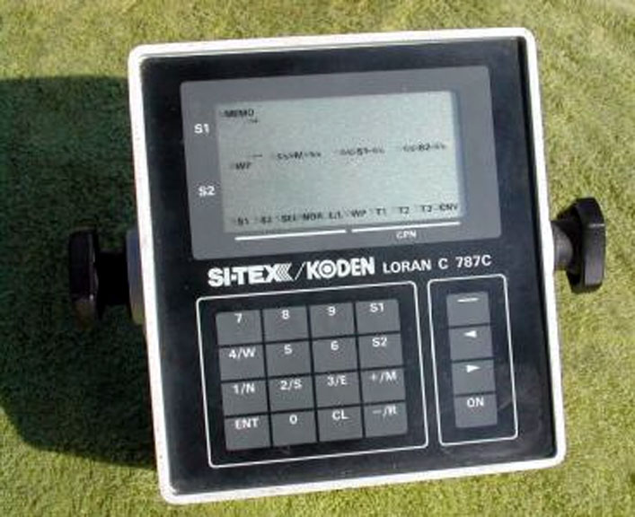
I personally use an old Si-Tex 787C, but almost any
similar unit available on e-Bay will work as well. Be
careful when you see old Si-Tex LORANs with "XJ"
designators. The XJ1 and XJ9 were excellent units, but
XJ units with numbers between 1 and 9 (such as XJ2)
were "odd-ball" units that incorporated some
sort of architecture by Ross.
I don't suggest that they aren't reliable, but they
will not take you to the
same place as was recorded by any other Si-Tex LORAN. |
 |
There appears to be good news on the horizon.
As I said in my introduction to this project,
"Shopping for a LORAN these days is about
like shopping for an 8-Track player . . . Mark my words
-- that will change."
I said that because the Coast Guard has been pouring money
into upgrading the LORAN system and the Department of Homeland
Security is pushing it - along with virtually everybody who
is anybody from MIT to the Royal Navy. Based upon my research
and everything I was reading, I believed (and continue to
believe) that LORAN is going to be the focus of a great deal
of renewed attention.
And so it has. Si-Tex Marine recently announced the reintroduction
of LORAN into their product line - you can read their announcement
here:
http://www.si-tex.com/html/new_secure_navigation_system.html
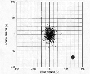 |
In order to visualize the reason why LORAN must be
used to chase down LORAN coordinates, and understand
why LORAN continues to be viable technology, I refer
you to a scatterplot published by MIT. A picture is
truly worth a thousand words.
Those of us who have used this equipment know that
there is a certain amount of "dither" inherent
in these systems. This is what you get when you plot
the GPS and LORAN fixes of a STATIONARY object over
a 24 HR period. |
This tells the whole story eloquently. Study the scatter
plot and note the following:
1) GPS is much more accurate than LORAN. Throughout the
24 HR period, the GPS receiver reported fluctuating positions,
but the reported position was always within 100 meters of
it's true location and usually within 25 meters.
2) Although the LORAN receiver thought it was about 180
meters southeast of it's true position (measure to zero
point at center of chart), it was much more consistent;
it reported position fluctuations of no more than 15 meters
in any direction.
3) It would be futile to try and use the GPS to return to
the position marked by the LORAN - you could be as much
as 240 meters off (measure from extremes of each plot).
4) It could be frustrating to try and use the GPS to return
to the position marked by the GPS - you could be off by
as much as 150 meters (measure between extremes of GPS plot).
5) It would be simple to use the LORAN to return to a position
marked with the LORAN. You could expect to return to the
same position within 25 meters (measure between extremes
of LORAN plot).
In actuality, the difference is not as extreme as this scatterplot
depicts - the GPS plots were adversely effected by selective
availability (SA) and the LORAN plots were generated without
the benefit of ASF correction. I'll further address those
issues when I discuss the use of this equipment in an upcoming
report.
The point is, these are very different, complimentary technologies.
High frequency, low power, airwave signal propagation versus
low frequency, high power groundwave signal propagation. Considering
the critical significance to aviation and marine navigation,
why would the government abandon a reliable secondary system
like LORAN? They won't.
The potential here is especially obvious to any marksman
who understands the principal of "Kentucky Windage."
Look at the scatter plot again and imagine that it represents
a rifle target. Bear in mind that GPS makes it possible to
precisely correct for the LORAN's inherent error - imagine
what you would get if you "zeroed" the LORAN rifle
scope, adjusting it 137 meters west and 137 meters north!
Over the last ten years, the public's infatuation with new
technology has knocked the bottom out of the LORAN industry,
but Si-Tex is returning to it, and I believe that you can
expect that the other major manufacturers of marine related
equipment will follow suit - although what the others do probably
won't matter to me, or anyone trying to do what I am doing.
I say that because I had occasion to be aboard a lot of boats
during the course of my marine law enforcement career, so
I know for certain that most of the local commercial fishermen
have always relied heavily on Si-Tex equipment - probably
as much as ten-to-one. Therefore, most of the
time difference LORAN coordinates in circulation here in SW
Florida were recorded with Si-Tex equipment.
If the new Si-Tex LORAN/GPS/WAAS receivers report the same
TD's as the old ones did, it will be a one-stop shopping answer
to the first part of the problem, and I have no reason to
suspect that this will not be the case. At any rate, I will
have one of these new LORANs on my boat just as soon as they
hit the street; I'll operate it alongside my venerable 787
and find out whether it can be used to run down old numbers.
I'll report back on that so stay tuned!
So, to Jim Jones, at Walker's Marine, I would say that with
regard to this first aspect of the
situation, you can tell your Clients that it boils down to
this:
Anyone who hopes to run down the old time difference
coordinates needs a functional LORAN receiver, coupler and
the readily available whip antenna. They can either buy
used equipment and take their chances, or wait a month or
so until the new Si-Tex units become available.
In the meantime, it might be wise for them
to give the SONAR issue some thought. Whether they attempt
to use LORAN, GPS, DGPS, WAAS, or good old fashioned haruspicy
as their guide to navigation, they will need an effective
"bottom machine" to see what's down there, when
they get there.
That will be the subject of my next article.
I will address the use of this equipment
once we have it all introduced, and identified.
I
welcome your comments,
questions and suggestions. |